NAMIBIA
A BRIEF HISTORY
"Namibia may have been inhabited by the San peoples more than 2,000 years ago. The Bantu-speaking Herero settled there in the 1600s. The Ovambo, the largest ethnic group today, migrated in the 1800s. In the late 15th century, the Portuguese explorer Bartolomeu Dias became the first European to visit Namibia. Formerly called South-West Africa, the territory became a German colony in 1884. Between 1904 and 1908, German troops massacred tens of thousands of Herero, who had revolted against colonial rule. In 1915, during World War I, Namibian territory was taken over by South African forces. In 1921, it became a mandated territory of the League of Nations, under the administration of South Africa. Finally in 1990 Namibia achieved Nationhood"
About Namibia
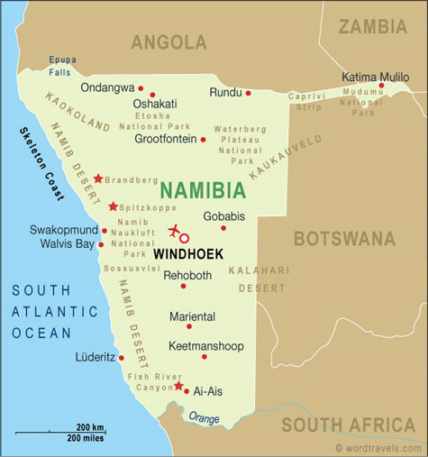
Namibia is located on the southwestern coastline of Africa, bordered by South Africa in the south, Botswana in the east, Angola and Zambia in the north and of course the cold Atlantic ocean in the west. An appendage called the Caprivi Strip juts out to the east. About 60% of Namibia is taken up by savannahs (grass plains, whuile the balance either consists of dunes or mountain terrain.
It is the 5th largest of the 19 African countries south of the equator, but the most sparsely populated. The population of Namibia is just under 2 million people and of very diverse population groups.
Namibia is still a very young country in terms of being independent, but incredibly old given the passage of time. Given the vast expanse of this country, the nature of roads, the only sensible method of exploring this beautiful country is by road i.e. self drive tours.
Exciting places to visit in Namibia are:
- Windhoek
- Etosha National Park
- Southern Namib
- Welwitchia Plain - Swakopmund
- Skeleton Coast National Park
- Brandberg Mountain
- Mudumo National Park & Linyanti Wildlife Reserve - Caprivi Strip
- Fish River Canyon
Windhoek
 Windhoek is the capital city of Namibia and the city is both the geographical and rconomic heart of the country. It is very Germanic in nature, located in the highlands. It is therefore surrounded by hills and mountains. The city center is characterized by historic German colonial
architecture and imposing modern structures. Dominating the skyline is
the striking German Lutheran church, Christuskirche, a mixture of Art
Nouveau and neo-Gothic design, and the Tintenpalast, or 'Ink Palace',
the parliament building from where the sparsely populated country is
governed. The
Windhoek is the capital city of Namibia and the city is both the geographical and rconomic heart of the country. It is very Germanic in nature, located in the highlands. It is therefore surrounded by hills and mountains. The city center is characterized by historic German colonial
architecture and imposing modern structures. Dominating the skyline is
the striking German Lutheran church, Christuskirche, a mixture of Art
Nouveau and neo-Gothic design, and the Tintenpalast, or 'Ink Palace',
the parliament building from where the sparsely populated country is
governed. The  railway station is a Cape Dutch edifice dating back to
1912 and Independence Avenue is a pleasant tree-lined place with
fountains and walkways providing a relaxing ambience among the modern
buildings of the central business district. The women of the Herero
tribe, cattle herders of the region, are very distinctive with their
voluminous Victorian-style dresses and colorful headgear.
railway station is a Cape Dutch edifice dating back to
1912 and Independence Avenue is a pleasant tree-lined place with
fountains and walkways providing a relaxing ambience among the modern
buildings of the central business district. The women of the Herero
tribe, cattle herders of the region, are very distinctive with their
voluminous Victorian-style dresses and colorful headgear.The German influence is not only apparent in the architecture and colonial style buildings, but is evident in the food and locally brewed beer. Polony and sauerkraut are available on the menu among local dishes, including seafood from the west coast and venison or game steaks from the hinterland - hence a very popular destination for German tourists. If you do not wish to drive around the train station is situated in the city center and TransNamib offers routes within Namibia, as does the tourist train, Desert Express.
___________________________________________________________________________________________________
Etosha National Park
 The Etosha National Park, 'great white place of dry water', is a vast area
of shimmering mirages and saline desert, savannah and scrubby woodlands
situated 435km north of Windhoek. Its unique landscape is
characterized by an immense flat white saltpan, a shallow depression
that is dry for the greater part of the year, but fed by moisture from
perennial springs on the fringes. The pan covers about 25 percent of
the park.
The Etosha National Park, 'great white place of dry water', is a vast area
of shimmering mirages and saline desert, savannah and scrubby woodlands
situated 435km north of Windhoek. Its unique landscape is
characterized by an immense flat white saltpan, a shallow depression
that is dry for the greater part of the year, but fed by moisture from
perennial springs on the fringes. The pan covers about 25 percent of
the park.Once a vast lake, the pan was fed by the Kunene River, which changed its course thousands of years ago, leaving a dry hollow of salt and cracked clay, which only fills up for a short while after heavy rain. The temporary water supply attracts thousands of water birds, including flocks of pink flamingos, during the rainy season, but the best time for viewing animals in Etosha is the cool, dry season, between May and September.
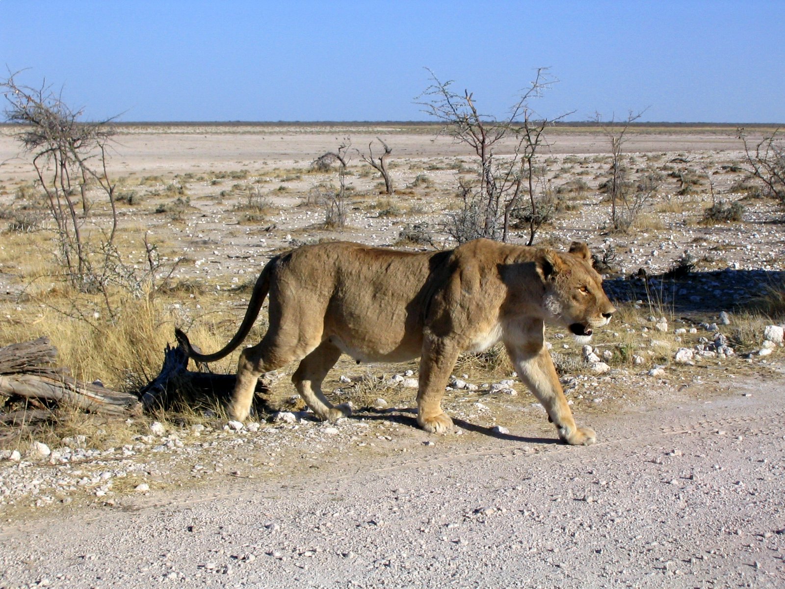
The salinity and rich mineral content of the pan attracts a huge diversity of animal and bird life to the park making it an excellent place for game viewing, with the expanse of the white desert an extraordinary backdrop. Etosha has a network of roads linking its three rest camps - Namutoni, Halali and Okaukuejo - all of which have floodlit waterholes allowing for superb night game viewing. Visitors can expect to see many species of antelope, wildebeest, zebra, lion, giraffe, and Africa's tallest elephants. Several of the animal species are endangered, including the black rhino. There are also opportunities to see leopard and cheetah around the many waterholes scattered throughout the park.
___________________________________________________________________________________________________
Southern Namib (Namib-Naukluft Park)
The southern Namib forms part of the Namib-Naukluft Park, one of Africa's most interesting and diverse nature reserves, including Sandwich Lagoon, an important wetland area for migratory birds, as well as canyons, rivers, and the Naukluft mountain massif, home to many species of animal, particularly the Hartmann's mountain zebra. This section of the Namib Desert is characterized by an endless sea of orange sand
 dunes, and the famous Sossusvlei dunes, the highest in the world.
___________________________________________________________________________________________________
Welwitchia Plains
The Welwitschia Plains are situated approximately 30 - 50 km
inland from Swakopmund, roughly lying between the Swakopmund River and
Khan River and were declared a world heritage site by Unesco in 2002. They form part of the hyper-arid gravel plains of the Namib
Desert. Most precipitation is in the form of fog, blowing in from the
sea to the west. The most notable feature of this area is the presence
of the highest concentration of Welwitschia mirahilis plants
(Welwitschia) in Namibia. Not only is the Welwitschia endemic to the
Namib Desert and semi-desert, it is also taxonomically very distinct,
being the only representative in its family, and only one of three
species in the order Gnetales.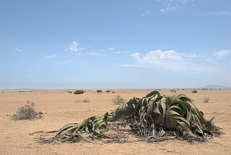
Some of the larger specimens (like those on the Plains) may be close to 2000 years old. On the central Namib gravel plains at the site, the Welwitschia plants are the dominant perennial vegetation.
___________________________________________________________________________________________________
Skeleton Coast National Park
The desolate coastline of the Skeleton Coast Park is a spooky desert shore with massive sand dunes and treacherous rocks where mighty storms and violent surf claimed many ships through the centuries. Stories abound of sailors walking for hundreds of kilometres through this barren Namibian landscape in search of food and water only to perish in this hostile coastal desert. The landscape includes sand dunes, canyons and mountain ranges all of which are synonymous with Namibia and the climate is seemingly strange for desert conditions: dense fog and cold sea breezes predominate, blown in by the cold Benguela Current.
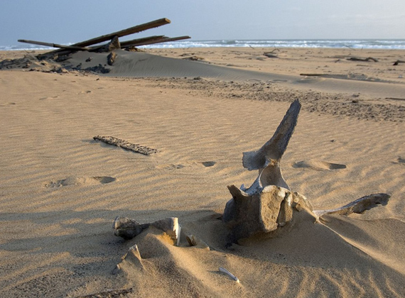
A fly-in safari or scenic flight is the best way to view the shipwrecks and coastal splendour of the park. Inattentive whales have also found themselves washed up along the shore and their massive bone structures are scattered along the coast. Animals in the park have been forced to adapt to overcome the problems of living in a desert-like climate. Smaller species such as genet, caracal, baboon, springbok, and brown hyena live in the area all year round. Larger animals, such as black rhinos, elephant and lion tend to migrate along the channels in search of precious food and water.
The primary wildlife attraction of the Skeleton Coast is Cape Cross, which harbours a seal colony numbering in the tens of thousands. The dunes are alive with reptiles and insects including geckos, snakes, spiders, wasps, beetles, and termites. The birds are found mostly along the rivers and some Namibian endemic species can be found in this area including one of the rarest terns in the world. Some 300,000 waders visit annually, mainly flamingos and pelicans.
____________________________________________________________________________________________________
Brandberg Mountain
The Brandberg with its highest peak
Königstein (2606 m above sea level) is the highest mountain in Namibia and a National
Monument. The geological history of Brandberg is just as interesting as the thousands of rock art
paintings and engravings on the mountain and its surroundings. The Brandberg itself is not
a volcano but is a granite plug which was pressed out of the volcano's pipe and stopped at
about 10 000 meters under the surface. That is why the granite of the Brandberg is younger
than the Dolorite which lies around the Brandberg.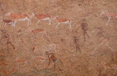
The Brandberg is better known for its rock paintings and carvings, of which the ''White lady'' is the best known. This painting, located in the Tsisab Ravine, is about 2000 years old and can be reached after about 1.5 hours walk. The visit to the painting is best to be done early in the morning or late afternoon to avoid extreme heat of the midday. The ''White Lady'' was presumably painted by San people.
More than 43 000 individual paintings were located in the Brandberg combining in around 1000 sites. Although the Brandberg is not one of the highest mountains in the world, it is the third highest in Africa. The Brandberg is an Eco system on its own with a plants like Brandberg acacia that grows on the Brandberg and within its surroundings
___________________________________________________________________________________________________
Mudumo National Park & Linyanti Wildlife Reserve (Caprivi Strip)
This lush savannah area is bounded by the Kwando,
Linyanti and Chobe River system on the southern border with Botswana.
From a wildlife and African travel point of view, it is the Chobe River
boundary which is most renowned for the amazing wildlife experiences it
delivers. Wildlife in the Caprivi has not yet recovered from years of
poaching and the destructive bushwar of the 70's and 80's, but its
superb conservation areas may in the future rival Etosha. Almost 70% of
the bird species found in Namibia have been recorded in the Caprivi.
The Chobe River system delivers a great diversity of these as well.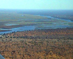
Mudumu is known for its buffalo population, roan and sable antelope, red lechwe and the water-dependent sitatunga together with large elephant herds. General mammal diversity is good including lion, hippo, impala, Burchell’s zebra, greater kudu and common waterbuck, reedbuck and bushbuck. The waterways here are home to spotted-necked otter, ferocious tigerfish, and several large Nile crocodile.
There are three main features of the Linyanti Concession: the Linyanti River, the woodlands of the interior and the well-known Savuti Channel, famous as a sporadic and unusual watercourse. The Channel last flowed in 1980 (but has again begun to show signs that the flow is returning) ;today it is mostly an open grassland and home to a wide variety of animals.
___________________________________________________________________________________________________
Fish River Canyon
A hike through the Canyon can and may only be done in winter, between April 15 and September 15. In summer, the temperatures in the gorge are extreme; even in winter, conditions get quite hot. In the past, many accidents and even fatalities have occurred, mainly due to heat stroke and heart failure. The rescue facilities are limited; no helicopters are stationed nearby and there is no cell phone reception in the Canyon.
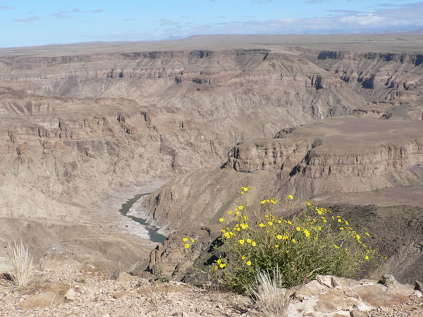
The descent starts at Hiker's View, about 3 km north of the Main Viewpoint and takes almost an hour. Only one "emergency exit" leads out of the gorge near "Palm Springs", to which one usually arrives at on the third day. It is a very steep path and once you get to the top, you literally stand in the desert. The trail ends in Ai-Ais.
For more information visit our website or contact us by E-mail.
