A BRIEF HISTORY
"The history of Botswana does much more than cover a gap between the histories of neighbouring South Africa and Zimbabwe, Namibia, Angola, and Zambia. In prehistoric and very recent times the Kalahari thirstlands of Botswana have been central in the historical geography of the region, as the intermediate territory between the savannas of the north and east and the steppes of the south and west.
Between the 1880s and its independence in the 1960s, however, Botswana was a poor and peripheral British protectorate known as Bechuanaland. The country is named after its dominant ethnic group the Tswana or Batswana ('Bechuana' in older variant orthography), and the national language is called Setswana (aka 'Sechuana').
Since the later 1960s Botswana has gained in international
stature as a peaceful and increasingly prosperous democratic state. It has had one of the fastest
growing economies in the world, rising from
one of the poorest to lower-middle income level. This new
prosperity has been based on the mining of diamonds and other
minerals, which have built up state revenues, and on the sale of to Europe and the world market. There has been extensive
development of educational and health
facilities, in villages and traditional rural towns as well as in
rapidly growing new towns."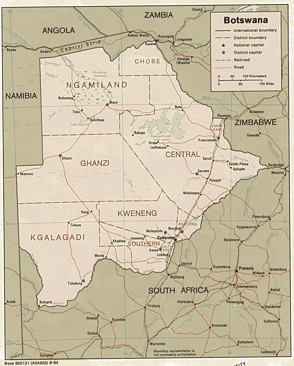
About Botswana
Today Botswana is one of the most progressive and successful on the African continent, with dramatically improved overall health care and educational systems. Most of the country's population base congregates in the eastern savanna grasslands, along its borders with South Africa and Zimbabwe. Botswana's economy is given a serious boost by being the world's third-largest producer of diamonds, and a large exporter of beef to Europe. In addition, it has a solid level of tourism, boosted by a series of national parks, including the Chobe NP, and the Okavango Delta wildlife areas in the north.
Exciting places to visit in Botswana are:
- Okavango Delta
- Moremi Game reserve
- Chobe National Park
- Kgalagadi National (Gemsbok) Transfrontier Park
- Makgadikgadi Pans National Park
Okavango Delta
The Okavango Delta is one of the world’s largest inland water systems.
It's headwaters start in Angola’s western highlands, with numerous
tributaries joining to form the Cubango river, which then flows through
Namibia (called the Kavango) and finally enters Botswana, where it is
then called the Okavango.
Millions of years ago the Okavango river use to flow into a large inland lake called Lake Makgadikgadi (now Makgadikgadi Pans). Tectonic
activity and faulting interrupted the flow of the river causing it to
backup and form what is now the Okavango delta. This has created a
unique system of water ways that now supports a vast array of animal
and plant life that would have otherwise been a dry Kalahari savanna.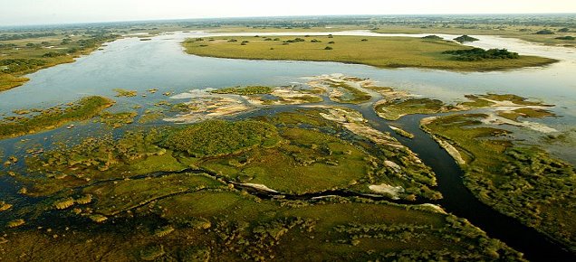
The
delta’s floods are fed from the Angolan rains, which start in October
and finish sometime in April. The floods only cross the border between
Botswana and Namibia in December and will only reach the bottom end of
the delta (Maun) sometime in July. Taking almost nine months
from the source to the bottom. This slow meandering pace of the flood
is due to the lack of drop in elevation, which drops a little more than
60 metres over a distance of 450 kilometres. The delta’s water deadends
in the Kalahari – via the Botetle river, with over 95 per cent of the
water eventually evaporating.
During the peak of the flooding
the delta’s area can expand to over 16,000 square kilometres, shrinking
to less than 9,000 square kilometres in the low period. As the water
travels through the delta, the wildlife starts to move back into the
region. The areas surrounding the delta are beginning to try out
(the rains in Botswana occur approximately the same time as in Angola)
and the wildlife starts to congregate on the edge of the newly flooded
areas, May through October.
The delta environment has large
numbers of animal populations that are otherwise rare, such as
crocodile, red lechwe, sitatunga, elephant, wild dogs, buffalo, wattled
crane as well as the other more common mammals and bird life. The
best time for game viewing in the delta is during the May-October
period, as the animal life is concentrated along the flooded areas and
the vegetation has dried out.
The best time for birding and vegetation is during the rainy season (Nov.- April) as the migrant bird populations are
returning and the plants are flowering and green.
___________________________________________________________________________________________________
Moremi Game Reserve
Moremi covers some 4,871 km2, as the eastern section of
the Okavango Delta. Moremi is mostly described as
one of the most beautiful wildlife reserves in Africa as it combines mopane woodland and
acacia forests, floodplains and lagoons.
mostly described as
one of the most beautiful wildlife reserves in Africa as it combines mopane woodland and
acacia forests, floodplains and lagoons.
It is the great diversity of plant and animal life that makes Moremi so well known. The
reserve contains within its boundaries approximately twenty percent of the Okavango Delta.
There are a wide range of habitats in Moremi; from riparian woodlland, floodplain, reed
beds, permanent wetland through mopane forest to dry savanna woodland. The mainland part
forms only about thirty percent of the reserve and is, in many ways untypical - the
remaining area being part of the Okavango Delta.
___________________________________________________________________________________________________
Chobe National Park
The park is divided
into four dist inctly different eco systems: Serondela with its lush
plains and dense forests in the Chobe River area in the extreme north-east; the Savuti Marsh in the west about
fifty kilometres north of Mababe gate; the Linyanti Swamps in the
north-west and the hot dry hinterland in between.
inctly different eco systems: Serondela with its lush
plains and dense forests in the Chobe River area in the extreme north-east; the Savuti Marsh in the west about
fifty kilometres north of Mababe gate; the Linyanti Swamps in the
north-west and the hot dry hinterland in between.
The Chobe River has its origins in the highlands of Angola and once it enters Botswana, it goes through several name changes. It enters as the Kwando River and immediately becomes the Linyanti, then the Itenge and is finally called the Chobe River. Knowing this may avoid confusion when looking at maps or reading information.
The most popular area in and just outside Chobe National Park is the short 9-mile (15km) stretch of Chobe River from Kasane town to the Serondela campsite. Few people come to Chobe without taking a trip on this river to see hundreds of hippopotamuses and crocodiles. Both hippo's and elephants epitomise this park more than any other animals and are often featured on the cover of brochures to the area. The only subject more photographed in Chobe are the exquisite sanguine sunsets sinking slowly over the water.
Chobe National Park is probably the most affordable of Botswana's parks and with the lure of excellent game watching both on and beside the river, the well frequented areas can become quite crowded.
___________________________________________________________________________________________________
Kgalagadi National (Gemsbok) Transfrontier Park
The Gemsbok National Park (Botswana) and the Kalahari Gemsbok Park
(South Africa) have been formed into one unit creating the first of a series of 8 Frontier
Parks to be established in Southern Africa - the Kgalagadi Transfrontier Park.
The absence of man-made barriers (except to the west and south of the Park) has provided a conservation area large enough to maintain examples of
two ecological processes that were once widespread in the savannahs and grasslands of
Africa. The large scale migratory movements of wild ungulates; and predation by large
mammalian carnivores.
provided a conservation area large enough to maintain examples of
two ecological processes that were once widespread in the savannahs and grasslands of
Africa. The large scale migratory movements of wild ungulates; and predation by large
mammalian carnivores.
It is a vast area of unspoilt countryside with low vegetation-covered dunes, grasslands,
scrub bush and woodlands. Its pans are bordered by high peripheral dunes. The pans fill up
with water during the rainy season and contain nutrient-rich soils, and salts.
In the southern part of near Bokspits, are large, red dunes which are a spectacle to watch
and a challenge to climb. Because of its tough terrain, many parts remain virgin waiting
to be experienced.
Despite this dryness and low rainfall, the Kalahari supports a diverse and abundant mammal
fauna. The best time to visit the park is towards the end of the rainy season, roughly
March to May, however, game can he seen at any time of the year. The area supports
numerous Kalahari ungulates which include wildebeest, eland, hartebeest, gemsbok and
springbok, and a healthy population of large predators - lions, leopards, cheetah and
hyena.
___________________________________________________________________________________________________
Makgadikgadi Pans National Park
 West of Gweta, the tar road road to Maun slices through
Makgadikgadi and Nxai National Park. Because of their complementary
natures regarding wildlife migrations, Makgadikgadi Pans Game Reserve and Nxai Pan National Park
were established concurrently in the early 1970s, in the hope of
protecting the entire ecosystem.
West of Gweta, the tar road road to Maun slices through
Makgadikgadi and Nxai National Park. Because of their complementary
natures regarding wildlife migrations, Makgadikgadi Pans Game Reserve and Nxai Pan National Park
were established concurrently in the early 1970s, in the hope of
protecting the entire ecosystem.
In December of 1992 the area of the Nxai Pan National Park was extended south to the main Gweta/Maun road, so it adjoins the Makgadikgadi Pans Game Reserve, which was renamed "The Makgadikgadi Pans National Park" to form one vast area covering just under 7,500km2. The park incorporates Ntwetwe Pan, Makgadikgadi Pans, Nxai Pan, Baines' Baobabs and Kudiakam Pan. Visitors to either section must pay park and camping fees at either the Xhumaga or Nxai Pan Game scout camp.
Four wheel drive is recommended throughout this area, as even in the dry season the pan surface can be treacherous with the unseen water table lurking often just inches under the hard-baked surface. Once on the pans the exhilaration of speeding across the flat surface in unforgettable.
While there are no fixed lodges or hotels in the park, there are several designated campsites. This limits access to all but the fully equipped self-drive visitor, or those on tailor-made safaris.
___________________________________________________________________________________________________